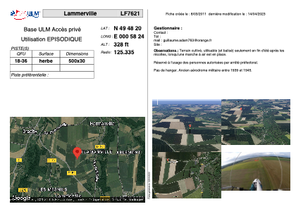
LF7621 - Lammerville
Located in Lammerville, France
ICAO - , IATA -
Data provided by AirmateGeneral information
Coordinates: N49°48'20" E0°58'24"
Elevation is 328 feet MSL.
View others Airports in Upper Normandy
Operational data
Special qualification required
Current time UTC:
Current local time:
Weather at : LFOS - Saint Valery Vittefleur ( 23 km )
METAR: Data unavailable at the moment
TAF: Data unavailable at the moment
Communications frequencies: [VIEW]
Runways:
| RWY identifier | QFU | Length (ft) | Width (ft) | Surface | LDA (ft) |
| 18 | 0° | 1640 | 98 | GRASS | |
| 36 | 0° | 1640 | 98 | GRASS |
Airport contact information
Address: Lammerville France