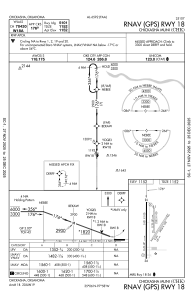
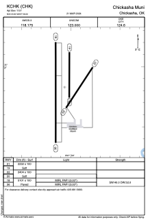
KCHK - Chickasha Muni
Located in Chickasha, United States
ICAO - CHK, IATA - CHK
Data provided by AirmateGeneral information
Coordinates: N35°5'50" W97°58'4"
Elevation is 1151 feet MSL.
Magnetic variation is 04° East View others Airports in Oklahoma
Operational data
Special qualification required
Current time UTC:
Current local time:
Communications frequencies: [VIEW]
Runways:
| RWY identifier | QFU | Length (ft) | Width (ft) | Surface | LDA (ft) |
| 01 | 0° | 2232 | 100 | GRASS | |
| 19 | 180° | 2232 | 100 | GRASS | |
| 02 | 33° | 2404 | 100 | GRASS | |
| 20 | 213° | 2404 | 100 | GRASS | |
| 18 | 180° | 5101 | 100 | CONC | |
| 36 | 0° | 5101 | 100 | CONC |
Airport contact information
Address: Chickasha United States