


WARR - Surabaya/Juanda
Located in Surabaya, Indonesia
ICAO - WARR, IATA - SUB
Data provided by AirmateGeneral information
Coordinates: S7°22'51" E112°47'11"
Elevation is 11 feet MSL.
View others Airports in Jawa Timur
Operational data
Special qualification required
Current time UTC:
Current local time:
Weather
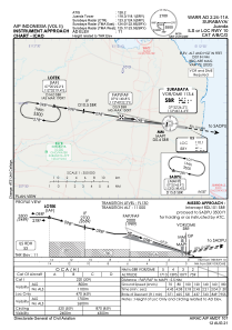
METAR: WARR 232000Z 27005KT 5000 HZ SCT020 26/25 Q1006 NOSIG
TAF: TAF WARR 231700Z 2318/2418 11005KT 8000 SCT020 BECMG 2320/2322 4000 HZ BECMG 2401/2403 9999 NSW PROB40 TEMPO 2406/2410 26010KT 4000 TSRA FEW018CB
Communications frequencies: [VIEW]
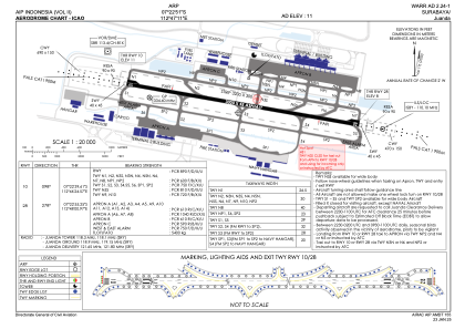
Runways:
| RWY identifier | QFU | Length (ft) | Width (ft) | Surface | LDA (ft) |
| 10 | 99° | 9843 | 148 | ASP | |
| 28 | 279° | 9843 | 148 | ASP |
Airport contact information
Address: Surabaya Indonesia