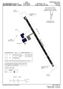


WAGM - Buntok/Sanggu
Located in Buntok, Indonesia
ICAO - , IATA -
Data provided by AirmateGeneral information
Coordinates: S1°40'6" E114°53'55"
Elevation is 23 feet MSL.
Magnetic variation is 0° East View others Airports in Kalimantan Timur
Operational data
Special qualification required
Current time UTC:
Current local time:
Weather at : - ( 0 km )
METAR: K40B 231716Z AUTO 19016G30KT 14/M05 A2992 RMK AO1 PK WND 19030/1703 SLP146 T01411051 58024
Communications frequencies: [VIEW]
Runways:
| RWY identifier | QFU | Length (ft) | Width (ft) | Surface | LDA (ft) |
| 15 | 150° | 2461 | 75 | UNK | |
| 33 | 330° | 2461 | 75 | UNK |
Airport contact information
Address: Buntok Indonesia