


WABA - Deiyai/Waghete Baru
Located in , Indonesia
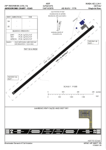
ICAO - , IATA -
Data provided by AirmateGeneral information
Coordinates: S4°3'33" E136°16'55"
Elevation is 1779 feet MSL.
Magnetic variation is 2° East View others Airports in Papua
Operational data
Special qualification required
Current time UTC:
Current local time:
Weather at : - ( 0 km )
METAR: TXKF 192055Z 26012KT 9999 BKN016 BKN140 22/18 Q1015
Communications frequencies: [VIEW]
Runways:
| RWY identifier | QFU | Length (ft) | Width (ft) | Surface | LDA (ft) |
| 04 | 0° | 4593 | 75 | UNK | |
| 22 | 0° | 4593 | 75 | UNK |
Airport contact information
Address: Indonesia