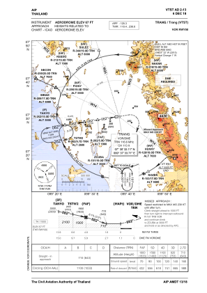
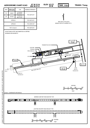


VTST - Trang / Trang Airport
Located in Trang, Thailand
ICAO - VTST, IATA - TST
Data provided by AirmateGeneral information
Coordinates: N7°30'31" E99°36'57"
Elevation is 67 feet MSL.
View others Airports in Trang Province
Operational data
Special qualification required
Current time UTC:
Current local time:
Weather
METAR: VTST 231200Z 15004KT 9999 FEW030 SCT050 31/27 Q1004 NOSIG
TAF: TAF VTST 231100Z 2312/2412 20005KT 9999 SCT030 TEMPO 2312/2316 -TSRA FEW018CB SCT020 BKN100 BECMG 2316/2318 06005KT BECMG 2404/2406 22006KT
Communications frequencies: [VIEW]
Runways:
| RWY identifier | QFU | Length (ft) | Width (ft) | Surface | LDA (ft) |
| 08 | 81° | 7612 | 148 | ASP | |
| 26 | 261° | 7612 | 148 | ASP |
Airport contact information
Address: Trang Thailand