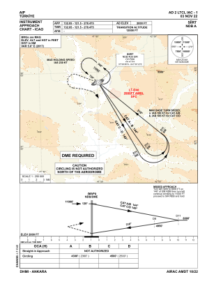
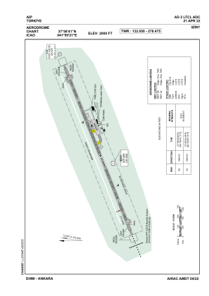


LTCL - Siirt
Located in Siirt, Turkey
ICAO - LTCL, IATA - SXZ
Data provided by AirmateGeneral information
Coordinates: N37°58'41" E41°50'21"
Elevation is 2000 feet MSL.
Magnetic variation is 5.6° East View others Airports in Siirt
Operational data
Special qualification required
Current time UTC:
Current local time:
Weather
METAR: LTCL 241250Z 25008KT CAVOK 30/12 Q1014
TAF: TAF LTCL 241040Z 2412/2421 24006KT CAVOK
Communications frequencies: [VIEW]
Runways:
| RWY identifier | QFU | Length (ft) | Width (ft) | Surface | LDA (ft) |
| 06 | 68° | 6562 | 98 | CONC | 6562 |
| 24 | 248° | 6562 | 98 | CONC | 6562 |
Airport contact information
Address: Siirt Turkey