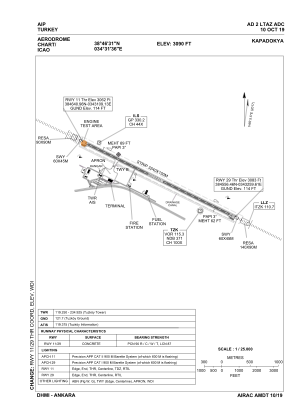


LTAZ - Kapadokya
Located in Nevsehir, Turkey
ICAO - LTAZ, IATA - NAV
Data provided by AirmateGeneral information
Coordinates: N38°46'31" E34°31'36"
Elevation is 3090 feet MSL.
Magnetic variation is 5.5° East View others Airports in Nevsehir
Operational data
Special qualification required
Current time UTC:
Current local time:
Weather
METAR: LTAZ 192320Z 03003KT 360V170 CAVOK 12/05 Q1010 RMK RWY29 02004KT
TAF: TAF LTAZ 192240Z 2000/2024 VRB02KT CAVOK BECMG 2006/2009 22018G28KT FEW040 SCT100 TEMPO 2009/2013 -TSRA FEW027CB BKN030 PROB40 TEMPO 2013/2017 18030G40KT -TSRA FEW027CB BKN035 BECMG 2017/2019 24008KT
Communications frequencies: [VIEW]
Runways:
| RWY identifier | QFU | Length (ft) | Width (ft) | Surface | LDA (ft) |
| 11 | 117° | 9843 | 148 | CONC | 9843 |
| 29 | 297° | 9843 | 148 | CONC | 9843 |
Airport contact information
Address: Nevsehir Turkey