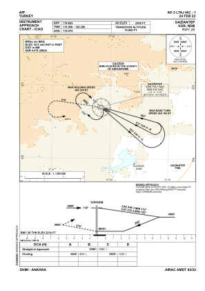
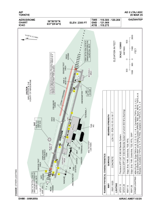


LTAJ - Gaziantep
Located in Gaziantep/Oguzeli, Turkey
ICAO - LTAJ, IATA - GZT
Data provided by AirmateGeneral information
Coordinates: N36°56'52" E37°28'44"
Elevation is 2305 feet MSL.
Magnetic variation is 5.3° East View others Airports in Gaziantep
Operational data
Special qualification required
Current time UTC:
Current local time:
Weather
TAF: TAF LTAJ 252240Z 2600/2624 VRB02KT CAVOK
Communications frequencies: [VIEW]
Runways:
| RWY identifier | QFU | Length (ft) | Width (ft) | Surface | LDA (ft) |
| 10 | 105° | 9843 | 157 | CONC | 9416 |
| 28 | 285° | 9843 | 157 | CONC | 9843 |
Airport contact information
Address: Gaziantep/Oguzeli Turkey