


KLNS - Lancaster
Located in Lancaster, United States
ICAO - LNS, IATA - LNS
Data provided by AirmateGeneral information
Coordinates: N40°7'20" W76°17'40"
Elevation is 402 feet MSL.
Magnetic variation is -09° East View others Airports in Pennsylvania
Operational data
Special qualification required
Current time UTC:
Current local time:
Weather
METAR: KLNS 231153Z 00000KT 10SM CLR 06/02 A3017 RMK AO2 SLP216 T00610022 10072 20011 53017
TAF: KLNS 231120Z 2312/2412 VRB04KT P6SM SKC FM231700 19007KT P6SM SCT160 FM232100 20010G17KT P6SM SCT250 FM240500 17008KT P6SM OVC100 FM240800 25006KT P6SM -RA OVC050
Communications frequencies: [VIEW]
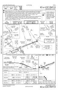
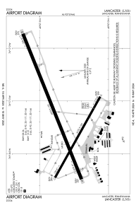
Runways:
| RWY identifier | QFU | Length (ft) | Width (ft) | Surface | LDA (ft) |
| 08 | 68° | 6933 | 150 | ASPH | 6118 |
| 26 | 248° | 6933 | 150 | ASPH | 6118 |
| 13 | 119° | 4102 | 100 | ASPH | 4102 |
| 31 | 299° | 4102 | 100 | ASPH | 4102 |
Airport contact information
Address: Lancaster United States
