


KELY - Ely/Yelland Fld
Located in Ely, United States
ICAO - ELY, IATA - ELY
Data provided by AirmateGeneral information
Coordinates: N39°17'59" W114°50'31"
Elevation is 6259 feet MSL.
Magnetic variation is 14° East View others Airports in Nevada
Operational data
Special qualification required
Current time UTC:
Current local time:
Weather
METAR: KELY 242253Z AUTO 15015G23KT 10SM SCT110 20/M06 A2988 RMK AO2 WSHFT 2225 SLP057 T02001056
TAF: KELY 242320Z 2500/2524 17015G25KT P6SM SCT080 FM250300 20010KT P6SM VCSH BKN080 FM251800 27010G20KT P6SM VCTS BKN050CB
Communications frequencies: [VIEW]
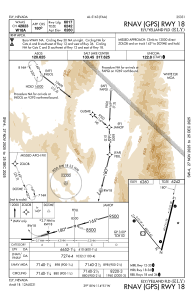
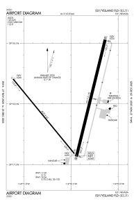
Runways:
| RWY identifier | QFU | Length (ft) | Width (ft) | Surface | LDA (ft) |
| 12 | 141° | 4825 | 60 | ASPH | |
| 30 | 321° | 4825 | 60 | ASPH | |
| 18 | 194° | 6017 | 150 | ASPH | |
| 36 | 14° | 6017 | 150 | ASPH |
Airport contact information
Address: Ely United States