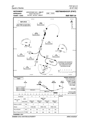
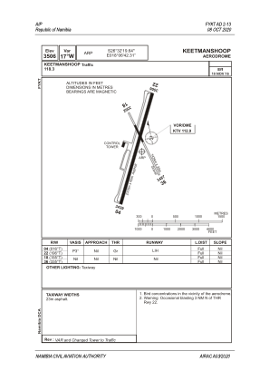


FYKT - Keetmanshoop
Located in Keetmanshoop, Namibia
ICAO - FYKT, IATA - KMP
Data provided by AirmateGeneral information
Coordinates: S26°32'20" E18°6'42"
Elevation is 3506 feet MSL.
View others Airports in Karas
Operational data
Special qualification required
Current time UTC:
Current local time:
Weather
TAF: TAF FYKT 181600Z 1818/1918 04005KT CAVOK
Communications frequencies: [VIEW]
Runways:
| RWY identifier | QFU | Length (ft) | Width (ft) | Surface | LDA (ft) |
| 04 | 16° | 7598 | 148 | ASP | |
| 22 | 196° | 7598 | 148 | ASP | |
| 18 | 155° | 4705 | 98 | GVL | |
| 36 | 335° | 4705 | 98 | GVL |
Airport contact information
Address: Keetmanshoop Namibia