


A32 - Butte Valley
Located in Dorris, United States
ICAO - A32, IATA -
Data provided by AirmateGeneral information
Coordinates: N41°53'14" W121°58'32"
Elevation is 4243 feet MSL.
Magnetic variation is 18° East View others Airports in California
Operational data
Special qualification required
Current time UTC:
Current local time:
Weather at : KLMT - Crater Lake/Klamath Rgnl ( 36 km )
METAR: KLMT 251653Z 25003KT 10SM OVC065 09/02 A2997 RMK AO2 SLP134 T00890022
TAF: KLMT 251731Z 2518/2618 25009KT P6SM VCSH OVC060 FM252000 25015G23KT P6SM -RA OVC040 FM252300 26009KT P6SM VCSH OVC050
Communications frequencies: [VIEW]
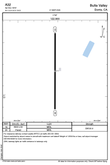
Runways:
| RWY identifier | QFU | Length (ft) | Width (ft) | Surface | LDA (ft) |
| 16 | 179° | 4300 | 60 | ASPH | |
| 34 | 359° | 4300 | 60 | ASPH |
Airport contact information
Address: Dorris United States