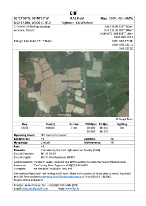


EIIF - Ilas Airfield
Located in 18.5Nm E Of Waterford City, Ireland
ICAO - , IATA -
Data provided by AirmateGeneral information
Coordinates: N52°17'44" W6°40'53"
Elevation is 140 feet MSL.
Magnetic variation is -2° East View others Airports in County Westmeath
Operational data
Special qualification required
Current time UTC:
Current local time:
Communications frequencies: [VIEW]
Runways:
| RWY identifier | QFU | Length (ft) | Width (ft) | Surface | LDA (ft) |
| 18 | 0° | 1969 | 49 | GRAS | 1772 |
| 36 | 0° | 1969 | 49 | GRAS | 1870 |
Airport contact information
Address: 18.5Nm E Of Waterford City Ireland
Web: https://ilas.ie/