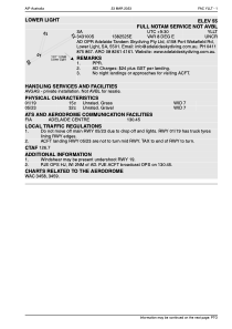


YLLT - Lower Light
Located in Lower Light, Australia
ICAO - , IATA -
Data provided by AirmateGeneral information
Coordinates: S34°30'60" E138°25'25"
Elevation is 55 feet MSL.
Magnetic variation is 8° East View others Airports in South Australia
Operational data
Special qualification required
Current time UTC:
Current local time:
Communications frequencies: [VIEW]
Runways:
| RWY identifier | QFU | Length (ft) | Width (ft) | Surface | LDA (ft) |
| 01 | 15° | 1715 | 22 | DIRT | |
| 29 | 0° | 0 | 0 | UNK | |
| 05 | 59° | 3026 | 51 | DIRT | |
| 23 | 239° | 3026 | 51 | DIRT | |
| 19 | 195° | 1715 | 22 | DIRT |
Airport contact information
Address: Lower Light Australia