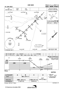
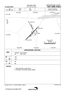


YHAY - Hay
Located in Hay, Australia
ICAO - YHAY, IATA - HXX
Data provided by AirmateGeneral information
Coordinates: S34°31'53" E144°49'47"
Elevation is 305 feet MSL.
View others Airports in New South Wales
Operational data
Special qualification required
Current time UTC:
Current local time:
Weather at : - ( 0 km )
METAR: EHWO 190925Z AUTO 29013G23KT 230V360 9999 DZRA FEW015CB SCT034 BKN047 09/08 Q1010 BLU TEMPO 29017G28KT 3500 SHRAGS SCT010 BKN015 SCT020CB
Communications frequencies: [VIEW]
Runways:
| RWY identifier | QFU | Length (ft) | Width (ft) | Surface | LDA (ft) |
| 04 | 44° | 4800 | 98 | ASP | |
| 22 | 224° | 4800 | 98 | ASP | |
| 15 | 155° | 3740 | 98 | GRE | |
| 33 | 335° | 3740 | 98 | GRE |
Airport contact information
Address: Hay Australia