


XA89 - Faith Ranch
Located in Carrizo Springs, United States
ICAO - XA89, IATA -
Data provided by AirmateGeneral information
Coordinates: N28°12'31" W100°1'8"
Elevation is 773 feet MSL.
Magnetic variation is 06° East View others Airports in Texas
Operational data
Special qualification required
Current time UTC:
Current local time:
Weather at : KCZT - Dimmit County ( 40 km )
METAR: KCZT 240055Z AUTO 12005KT 10SM BKN042 26/17 A2992 RMK AO2
Communications frequencies: [VIEW]
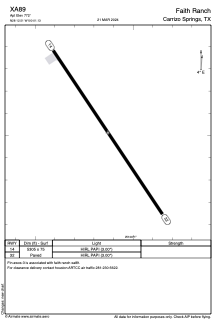
Runways:
| RWY identifier | QFU | Length (ft) | Width (ft) | Surface | LDA (ft) |
| 14 | 146° | 5305 | 75 | ASPH | |
| 32 | 326° | 5305 | 75 | ASPH |
Airport contact information
Address: Carrizo Springs United States