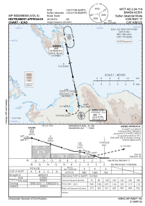
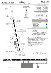


WITT - Banda Aceh/Sultan Iskandar Muda
Located in Banda Aceh, Indonesia
ICAO - WITT, IATA - BTJ
Data provided by AirmateGeneral information
Coordinates: N5°31'1" E95°25'12"
Elevation is 65 feet MSL.
View others Airports in Aceh
Operational data
Special qualification required
Current time UTC:
Current local time:
Weather
TAF: TAF WITT 242300Z 2500/2524 34005KT 9999 SCT019 PROB40 TEMPO 2506/2508 5000 TSRA FEW016CB BECMG 2512/2514 16004KT
Communications frequencies: [VIEW]
Runways:
| RWY identifier | QFU | Length (ft) | Width (ft) | Surface | LDA (ft) |
| 17 | 168° | 9843 | 148 | ASP | |
| 35 | 348° | 9843 | 148 | ASP |
Airport contact information
Address: Banda Aceh Indonesia