


WILP - Lampung / Muhammad Taufik Kiemas
Located in Lampung, Indonesia
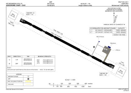
ICAO - , IATA - TFY
Data provided by AirmateGeneral information
Coordinates: S5°12'42" E103°56'22"
Elevation is 118 feet MSL.
View others Airports in Lampung
Operational data
Special qualification required
Current time UTC:
Current local time:
Weather at : - ( 0 km )
METAR: PAKU 192045Z 11018KT 10SM R06/P6000FT DRSN SCT007 SCT120 BKN150 M05/M06 A3020
Communications frequencies: [VIEW]
Runways:
| RWY identifier | QFU | Length (ft) | Width (ft) | Surface | LDA (ft) |
| 12 | 118° | 4265 | 98 | UNK | |
| 30 | 298° | 4265 | 98 | UNK |
Airport contact information
Address: Lampung Indonesia