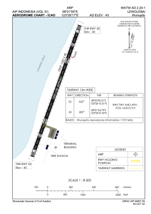


WATW - Lewoleba / Wunopito
Located in Lewoleba, Indonesia
ICAO - , IATA - LWE
Data provided by AirmateGeneral information
Coordinates: S8°21'44" E123°26'18"
Elevation is 43 feet MSL.
Magnetic variation is 1° East View others Airports in Nusa Tenggara Timur
Operational data
Special qualification required
Current time UTC:
Current local time:
Weather at : - ( 0 km )
METAR: CYPY 251608Z AUTO 19003KT 160V270 5SM BR OVC007 04/03 A2950 RMK SLP003
Communications frequencies: [VIEW]
Runways:
| RWY identifier | QFU | Length (ft) | Width (ft) | Surface | LDA (ft) |
| 02 | 26° | 3937 | 98 | UNK | |
| 20 | 206° | 3937 | 98 | UNK |
Airport contact information
Address: Lewoleba Indonesia