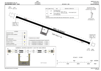


WAPS - Saumlaki / Mathilda Batlayeri
Located in Saumlaki, Indonesia
ICAO - , IATA -
Data provided by AirmateGeneral information
Coordinates: S7°50'53" E131°20'5"
Elevation is 452 feet MSL.
View others Airports in Maluku
Operational data
Special qualification required
Current time UTC:
Current local time:
Weather at : - ( 0 km )
METAR: CYPQ 201458Z AUTO 29010G17KT 9SM -RA SCT018 OVC060 04/01 A2992 RMK SLP142
Communications frequencies: [VIEW]
Runways:
| RWY identifier | QFU | Length (ft) | Width (ft) | Surface | LDA (ft) |
| 11 | 116° | 7546 | 148 | UNK | |
| 29 | 296° | 7546 | 148 | UNK |
Airport contact information
Address: Saumlaki Indonesia