


WAJG - Pegunungan Bintang / Batom
Located in , Indonesia
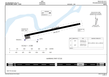
ICAO - , IATA - BXM
Data provided by AirmateGeneral information
Coordinates: S4°26'38" E140°52'54"
Elevation is 354 feet MSL.
Magnetic variation is 3° East View others Airports in Papua
Operational data
Special qualification required
Current time UTC:
Current local time:
Communications frequencies: [VIEW]
Runways:
| RWY identifier | QFU | Length (ft) | Width (ft) | Surface | LDA (ft) |
| 07 | 78° | 1312 | 75 | UNK | |
| 25 | 258° | 1312 | 75 | UNK |
Airport contact information
Address: Indonesia