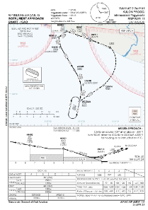
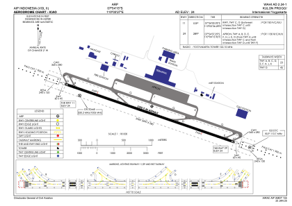


WAHI - Kulon Progo /Internasional Yogyakarta
Located in Yogyakarta, Indonesia
ICAO - , IATA - YIA
Data provided by AirmateGeneral information
Coordinates: S7°54'15" E110°3'27"
Elevation is 24 feet MSL.
View others Airports in Yogyakarta
Operational data
Special qualification required
Current time UTC:
Current local time:
Weather at : - ( 0 km )
METAR: YSRI 251951Z AUTO 00000KT 5000 // SCT001 08/08 Q1022 RF00.0/000.0
Communications frequencies: [VIEW]
Runways:
| RWY identifier | QFU | Length (ft) | Width (ft) | Surface | LDA (ft) |
| 11 | 110° | 10663 | 148 | UNK | |
| 29 | 290° | 10663 | 148 | UNK |
Airport contact information
Address: Yogyakarta Indonesia