


WAEM - Halmahera Island/Buli
Located in Buli, Indonesia
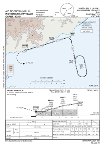
ICAO - , IATA - PGQ
Data provided by AirmateGeneral information
Coordinates: N0°55'10" E128°22'57"
Elevation is 88 feet MSL.
Magnetic variation is 0° East View others Airports in Maluku Utara
Operational data
Special qualification required
Current time UTC:
Current local time:
Weather at : - ( 0 km )
METAR: CYHD 231046Z AUTO 05011G20KT 020V080 2 1/2SM -SN FEW012 BKN025 BKN066 M00/M01 A2962 RMK SLP055
Communications frequencies: [VIEW]
Runways:
| RWY identifier | QFU | Length (ft) | Width (ft) | Surface | LDA (ft) |
| 07 | 74° | 3927 | 75 | UNK | |
| 25 | 254° | 3927 | 75 | UNK |
Airport contact information
Address: Buli Indonesia