


WAEB - North Halmahera / Marimoi
Located in Kao, Indonesia
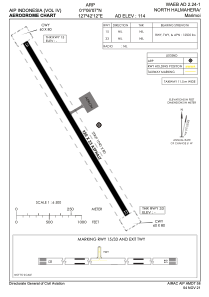
ICAO - , IATA -
Data provided by AirmateGeneral information
Coordinates: N1°6'7" E127°42'12"
Elevation is 114 feet MSL.
View others Airports in Maluku Utara
Operational data
Special qualification required
Current time UTC:
Current local time:
Weather at : - ( 0 km )
METAR: PAHX 180002Z AUTO 09010G16KT 10SM BKN045 OVC060 05/M02 A2993 RMK AO2 SLP135 60000 T00501017 10056 20028 56014
Communications frequencies: [VIEW]
Runways:
| RWY identifier | QFU | Length (ft) | Width (ft) | Surface | LDA (ft) |
| 15 | 0° | 3018 | 75 | UNK | |
| 33 | 0° | 3018 | 75 | UNK |
Airport contact information
Address: Kao Indonesia