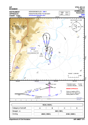


VYHL - Hommalinn
Located in Hommalinn, Myanmar
ICAO - VYHL, IATA - HOX
Data provided by AirmateGeneral information
Coordinates: N24°53'56" E94°54'51"
Elevation is 546 feet MSL.
View others Airports in Sagaing Division
Operational data
Special qualification required
Current time UTC:
Current local time:
Weather at : - ( 0 km )
METAR: KQEW 201110Z AUTO 03003KT 1600 -RA BR OVC008 13/13 A2982 RMK A02 TSNO
Communications frequencies: [VIEW]
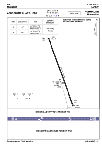
Runways:
| RWY identifier | QFU | Length (ft) | Width (ft) | Surface | LDA (ft) |
| 16 | 160° | 11998 | 200 | CON | |
| 34 | 340° | 11998 | 200 | CON |
Airport contact information
Address: Hommalinn Myanmar