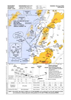
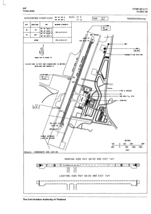


VTSR - Ranong / Ranong Airport
Located in Ranong, Thailand
ICAO - VTSR, IATA - UNN
Data provided by AirmateGeneral information
Coordinates: N9°46'39" E98°35'8"
Elevation is 57 feet MSL.
View others Airports in Ranong Province
Operational data
Special qualification required
Current time UTC:
Current local time:
Weather
TAF: TAF VTSR 251100Z 2512/2612 30005KT 9999 SCT020
Communications frequencies: [VIEW]
Runways:
| RWY identifier | QFU | Length (ft) | Width (ft) | Surface | LDA (ft) |
| 02 | 24° | 6562 | 148 | CON | |
| 20 | 204° | 6562 | 148 | CON |
Airport contact information
Address: Ranong Thailand