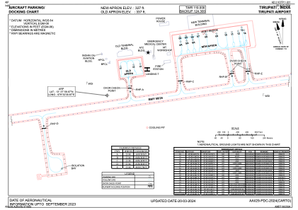


VOTP - Tirupati Airport
Located in Tirupati, India
ICAO - VOTP, IATA - TIR
Data provided by AirmateGeneral information
Coordinates: N13°37'59" E79°32'31"
Elevation is 350 feet MSL.
View others Airports in Andhra Pradesh
Operational data
Special qualification required
Current time UTC:
Current local time:
Weather
METAR: VOTP 251700Z 22009KT 6000 FEW020 33/23 Q1008 NOSIG
TAF: TAF VOTP 251700Z 2518/2624 22010KT 5000 HZ FEW020 TEMPO 2600/2603 VRB03KT 3000 BR SCT015 BECMG 2604/2606 16010KT 6000 SCT015 SCT025 BECMG 2620/2622 11007KT 5000 HZ SCT020
Communications frequencies: [VIEW]
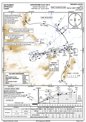
Runways:
| RWY identifier | QFU | Length (ft) | Width (ft) | Surface | LDA (ft) |
| 08 | 82° | 7497 | 148 | ASP | |
| 26 | 262° | 7497 | 148 | ASP |
Airport contact information
Address: Tirupati India