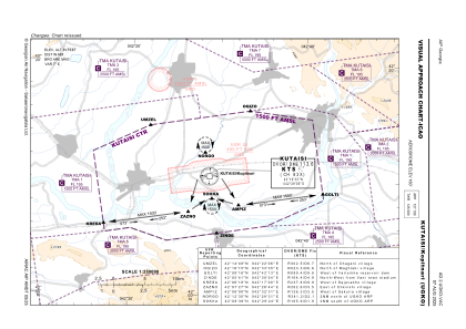
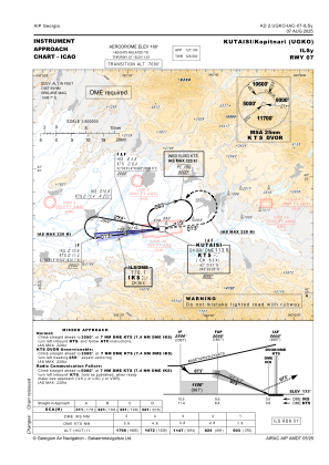
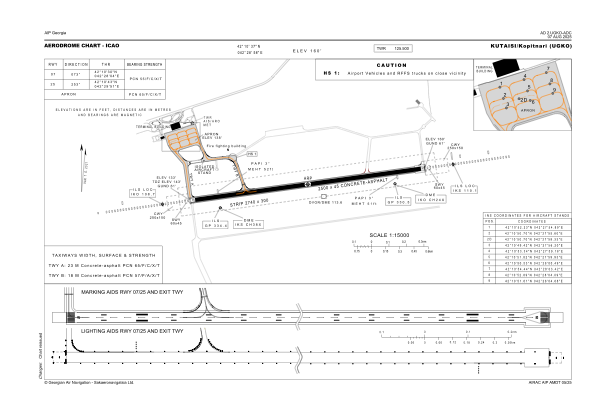


UGKO - Kutaisi/Kopitnari
Located in Kutaisi, Georgia
ICAO - UGKO, IATA - KUT
Data provided by AirmateGeneral information
Coordinates: N42°10'37" E42°28'58"
Elevation is 160 feet MSL.
Magnetic variation is 7° East View others Airports in Imereti
Operational data
Special qualification required
Current time UTC:
Current local time:
Weather
METAR: UGKO 191830Z 28004KT 9999 SCT038 14/12 Q1012 NOSIG
TAF: TAF UGKO 191700Z 1918/2018 26007KT CAVOK TX32/2011Z TN10/2003Z PROB40 TEMPO 1923/2005 0500 FG VV002 BECMG 2004/2006 08010KT TEMPO 2008/2018 08025G41KT
Communications frequencies: [VIEW]
Runways:
| RWY identifier | QFU | Length (ft) | Width (ft) | Surface | LDA (ft) |
| 07 | 80° | 8202 | 148 | CONC+ASPH | 8202 |
| 25 | 260° | 8202 | 148 | CONC+ASPH | 8202 |
Airport contact information
Address: Kutaisi Georgia