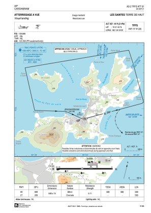


TFFS - Les Saintes Terre De Haut
Located in Terre De Haut, Guadeloupe
ICAO - TFFS, IATA - LSS
Data provided by AirmateGeneral information
Coordinates: N15°51'52" W61°34'50"
Elevation is 44 feet MSL.
Magnetic variation is -14.91° East View others Airports in (unassigned)
Operational data
Special qualification required
Current time UTC:
Current local time:
Weather at : TFFR - Pointe A Pitre Le Raizet ( 45 km )
METAR: TFFR 201200Z AUTO VRB02KT 9999 FEW024 28/24 Q1015 TEMPO 4000 SHRA BKN018TCU
TAF: TAF TFFR 201100Z 2012/2112 VRB02KT 9999 SCT020 TEMPO 2012/2112 3000 SHRA BKN016TCU BKN020 BECMG 2013/2015 12010KT PROB30 TEMPO 2015/2021 1400 TSRA SCT010CB BKN015TCU BECMG 2021/2023 VRB02KT
Communications frequencies: [VIEW]
Runways:
| RWY identifier | QFU | Length (ft) | Width (ft) | Surface | LDA (ft) |
| 09 | 74° | 1903 | 49 | CONC | 1903 |
| 27 | 254° | 1903 | 49 | CONC | 1903 |
Airport contact information
Address: Terre De Haut Guadeloupe