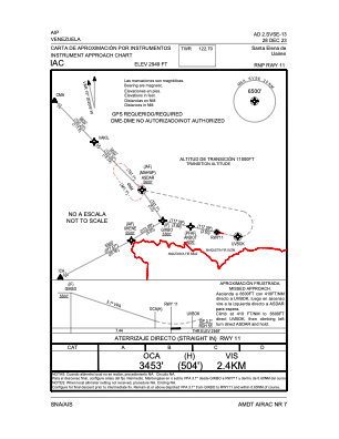
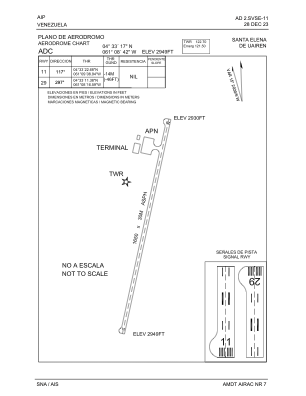


SVSE - Santa Elena De Uairen Ntl
Located in Santa Elena, Venezuela
ICAO - SVSE, IATA - SNV
Data provided by AirmateGeneral information
Coordinates: N4°33'17" W61°8'42"
Elevation is 2949 feet MSL.
Magnetic variation is -16° East View others Airports in Bolívar
Operational data
Special qualification required
Current time UTC:
Current local time:
Weather at : - ( 0 km )
METAR: PFKT 251625Z AUTO 11008KT 10SM -RA FEW007 BKN025 OVC050 02/01 A2982 RMK AO2 P0001 FZRANO
Communications frequencies: [VIEW]
Runways:
| RWY identifier | QFU | Length (ft) | Width (ft) | Surface | LDA (ft) |
| 11 | 102° | 5367 | 92 | ASPH | 5413 |
| 29 | 282° | 5367 | 92 | ASPH | 5413 |
Airport contact information
Address: Santa Elena Venezuela