


SOOS - Saul
Located in Saul, French Guiana
ICAO - SOOS, IATA - XAU
Data provided by AirmateGeneral information
Coordinates: N3°36'54" W53°12'13"
Elevation is 740 feet MSL.
Magnetic variation is -18.40° East View others Airports in Saint-Laurent-du-Maroni
Operational data
Special qualification required
Current time UTC:
Current local time:
Weather at : - ( 0 km )
METAR: CYMT 200832Z AUTO 22011G22KT 4SM -SNRA -UP BKN010 OVC015 00/M00 A2952 RMK SLP017
Communications frequencies: [VIEW]
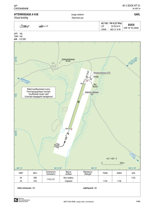
Runways:
| RWY identifier | QFU | Length (ft) | Width (ft) | Surface | LDA (ft) |
| 04 | 18° | 3747 | 157 | GRASS | 3747 |
| 22 | 198° | 3747 | 157 | GRASS |
Airport contact information
Address: Saul French Guiana