


SESV - San Vicente / Los Perales
Located in San Vicente, Ecuador
ICAO - SESV, IATA - BHA
Data provided by AirmateGeneral information
Coordinates: S0°36'28" W80°24'10"
Elevation is 10 feet MSL.
Magnetic variation is -3° East View others Airports in Manabi
Operational data
Special qualification required
Current time UTC:
Current local time:
Weather at : SEMT - Manta / Eloy Alfaro Intl ( 48 km )
METAR: SEMT 200500Z 15004KT 9999 SCT020 27/24 Q1011 RMK A2987
TAF: SEMT 192318Z 2000/2024 22006KT 9999 BKN026 BKN100 BECMG 2012/2013 VRB03KT BECMG 2015/2017 27008KT SCT026 SCT100 TX32/2020Z TN26/2010Z
Communications frequencies: [VIEW]
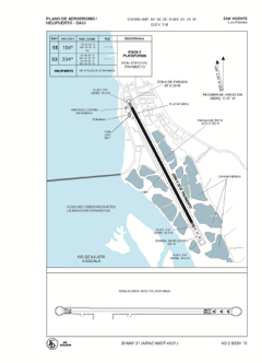
Runways:
| RWY identifier | QFU | Length (ft) | Width (ft) | Surface | LDA (ft) |
| 15 | 151° | 6773 | 94 | ASPH | 6755 |
| 33 | 331° | 6773 | 94 | ASPH | 5771 |
Airport contact information
Address: San Vicente Ecuador