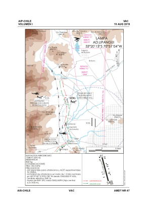


SCKL - Lipangui
Located in Lampa, Chile
ICAO - SCKL, IATA -
Data provided by AirmateGeneral information
Coordinates: S33°20'13" W70°51'4"
Elevation is 1558 feet MSL.
Magnetic variation is 1° East View others Airports in Santiago Metropolitan Region
Operational data
Special qualification required
Current time UTC:
Current local time:
Weather at : SCEL - Arturo Merino Benitez ( 8 km )
METAR: SCEL 191500Z 18008KT CAVOK 20/06 Q1016 NOSIG
TAF: TAF SCEL 191027Z 1912/2012 02004KT 7000 NSC TX27/1919Z TN07/2010Z BECMG 1915/1917 14005KT BECMG 1918/1920 20011KT BECMG 2003/2004 14007KT TEMPO 2009/2012 VRB02KT 3000 BR SCT002
Communications frequencies: [VIEW]
Runways:
| RWY identifier | QFU | Length (ft) | Width (ft) | Surface | LDA (ft) |
| 16 | 163° | 1502 | 48 | ASPH | |
| 34 | 343° | 1502 | 48 | ASPH |
Airport contact information
Address: Lampa Chile
