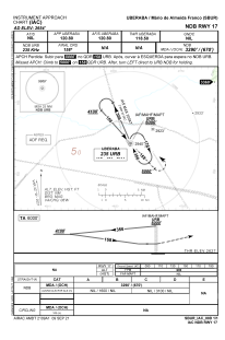
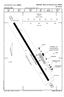


SBUR - Mário De Almeida Franco
Located in Uberaba, Brazil
ICAO - SBUR, IATA - UBA
Data provided by AirmateGeneral information
Coordinates: S19°45'53" W47°57'58"
Elevation is 2654 feet MSL.
Magnetic variation is -21.083333333° East View others Airports in Minas Gerais
Operational data
Special qualification required
Current time UTC:
Current local time:
Weather
METAR: SBUR 192200Z 18006KT CAVOK 25/20 Q1017
TAF: TAF SBUR 191630Z 1918/2006 13005KT 9999 SCT030 FEW045TCU TX29/1918Z TN21/2006Z PROB30 1918/1921 35010KT TS SCT030 FEW040CB BECMG 1921/1923 14005KT 9999 FEW025 BECMG 2000/2002 07013KT CAVOK PROB30 2003/2006 SCT003 RMK PHH
Communications frequencies: [VIEW]
Runways:
| RWY identifier | QFU | Length (ft) | Width (ft) | Surface | LDA (ft) |
| 17 | 0° | 5771 | 148 | ASPH | |
| 35 | 0° | 5771 | 148 | ASPH |
Airport contact information
Address: Uberaba Brazil