
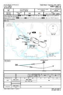


SBTT - Tabatinga / Tabatinga
Located in Tabatinga / Tabatinga, Brazil
ICAO - SBTT, IATA - TBT
Data provided by AirmateGeneral information
Coordinates: S4°15'2" W69°56'16"
Elevation is 263 feet MSL.
Magnetic variation is -10.0° East View others Airports in Amazonas
Operational data
Special qualification required
Current time UTC:
Current local time:
Weather
TAF: TAF SBTT 200904Z 2012/2112 02003KT 9999 SCT010 TX28/2019Z TN24/2111Z BECMG 2013/2015 7000 RA BKN015 BECMG 2016/2018 BKN020 FEW025TCU TEMPO 2018/2024 06007KT 4000 TSRA BKN015 FEW025CB BECMG 2100/2102 00000KT 3000 BR BKN004 RMK PFV
Communications frequencies: [VIEW]
Runways:
| RWY identifier | QFU | Length (ft) | Width (ft) | Surface | LDA (ft) |
| 12 | 115° | 2420 | 300 | ASPH | |
| 30 | 295° | 2420 | 300 | ASPH |
Airport contact information
Address: Tabatinga / Tabatinga Brazil