


SBSM - Santa Maria
Located in Santa Maria, Brazil
ICAO - SBSM, IATA - RIA
Data provided by AirmateGeneral information
Coordinates: S29°42'39" W53°41'32"
Elevation is 288 feet MSL.
Magnetic variation is -15° East View others Airports in Rio Grande do Sul
Operational data
Special qualification required
Current time UTC:
Current local time:
Weather
METAR: SBSM 250200Z 13004KT CAVOK 18/13 Q1017
TAF: TAF SBSM 242100Z 2500/2512 00000KT CAVOK TN14/2508Z TX19/2512Z BECMG 2502/2504 12005KT 9999 SCT020 RMK PDV
Communications frequencies: [VIEW]
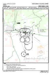
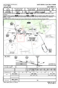
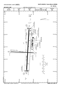
Runways:
| RWY identifier | QFU | Length (ft) | Width (ft) | Surface | LDA (ft) |
| 20 | 0° | 4938 | 98 | ASPH | |
| 11 | 0° | 8839 | 148 | CONC | |
| 29 | 0° | 8839 | 148 | CONC | |
| 02 | 0° | 4938 | 98 | ASPH |
Airport contact information
Address: Santa Maria Brazil