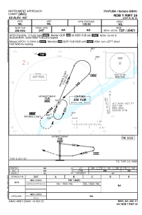


SBIH - Itaituba
Located in Itaituba, Brazil
ICAO - SBIH, IATA - ITB
Data provided by AirmateGeneral information
Coordinates: S4°14'32" W56°0'3"
Elevation is 101 feet MSL.
Magnetic variation is -18° East View others Airports in Pará
Operational data
Special qualification required
Current time UTC:
Current local time:
Weather
METAR: SBIH 191300Z 00000KT 9999 SCT008 27/25 Q1012
TAF: TAF SBIH 190916Z 1912/1924 06005KT 8000 SCT016 TX31/1918Z TN25/1924Z TEMPO 1912/1914 36005KT 4000 BR BKN010 BECMG 1915/1917 SCT017 FEW025TCU TEMPO 1918/1922 08007KT 7000 TS SCT020 FEW025CB RMK PHC
Communications frequencies: [VIEW]
Runways:
| RWY identifier | QFU | Length (ft) | Width (ft) | Surface | LDA (ft) |
| 06 | 0° | 1820 | 140 | ASPH | |
| 24 | 0° | 1820 | 140 | ASPH |
Airport contact information
Address: Itaituba Brazil