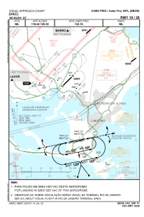
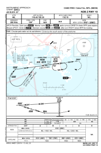
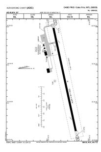


SBCB - Cabo Frio / Cabo Frio
Located in Cabo Frio, Brazil
ICAO - SBCB, IATA - CFB
Data provided by AirmateGeneral information
Coordinates: S22°55'15" W42°4'17"
Elevation is 23 feet MSL.
Magnetic variation is -23.0° East View others Airports in Rio de Janeiro
Operational data
Special qualification required
Current time UTC:
Current local time:
Weather
METAR: SBCB 231000Z 06007KT CAVOK 24/23 Q1015
TAF: TAF SBCB 230900Z 2312/2324 05010KT CAVOK TX30/2316Z TN25/2321Z BECMG 2314/2316 08010KT FEW025 RMK PHD
Communications frequencies: [VIEW]
Runways:
| RWY identifier | QFU | Length (ft) | Width (ft) | Surface | LDA (ft) |
| 10 | 77° | 2670 | 280 | ASPH | |
| 28 | 257° | 2670 | 280 | ASPH |
Airport contact information
Address: Cabo Frio Brazil