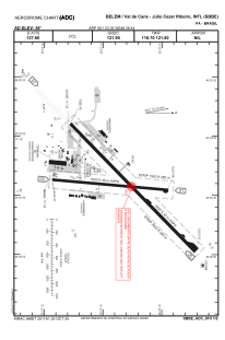


SBBE - Val De Cans - Júlio Cezar Ribeiro
Located in Belém, Brazil
ICAO - SBBE, IATA - BEL
Data provided by AirmateGeneral information
Coordinates: S1°23'5" W48°28'44"
Elevation is 55 feet MSL.
Magnetic variation is -20.0° East View others Airports in Pará
Operational data
Special qualification required
Current time UTC:
Current local time:
Weather
METAR: SBBE 251600Z 32007KT 8000 VCSH FEW015 SCT020 FEW025TCU BKN070 27/25 Q1010
TAF: TAF SBBE 251520Z 2518/2618 35010KT 8000 SCT030 FEW035TCU TN25/2609Z TX32/2616Z TEMPO 2518/2524 06010KT 5000 TSRA BKN025 FEW033CB BECMG 2600/2602 06005KT FEW015 TEMPO 2608/2612 12005KT 6000 BKN012 BECMG 2613/2616 33007KT SCT025 FEW030TCU TEMPO 2617/2618 04010KT 4000 TSRA BKN020 FEW030CB RMK PHC
Communications frequencies: [VIEW]
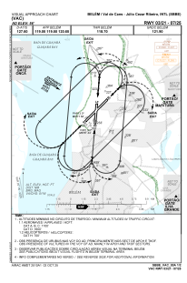
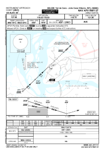
Runways:
| RWY identifier | QFU | Length (ft) | Width (ft) | Surface | LDA (ft) |
| 02 | 5° | 1950 | 300 | ASPH | |
| 20 | 185° | 1950 | 300 | ASPH | |
| 06 | 46° | 2920 | 300 | ASPH | |
| 24 | 226° | 2920 | 300 | ASPH |
Airport contact information
Address: Belém Brazil