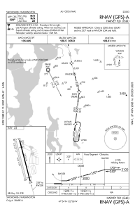


S43 - Harvey Fld
Located in Snohomish, United States
ICAO - S43, IATA -
Data provided by AirmateGeneral information
Coordinates: N47°54'18" W122°6'10"
Elevation is 23 feet MSL.
Magnetic variation is 17° East View others Airports in Washington
Operational data
Special qualification required
Current time UTC:
Current local time:
Weather at : KPAE - Snohomish County (Paine Fld) ( 13 km )
METAR: KPAE 201253Z AUTO 11004KT 10SM CLR 11/M07 A3002 RMK AO2 SLP167 T01111067
TAF: KPAE 201123Z 2012/2112 09007KT P6SM FEW200 FM201700 12012G19KT P6SM BKN120 OVC200 FM202100 18017G28KT P6SM BKN080 OVC120 FM210100 19017G27KT P6SM -SHRA BKN040 OVC060 FM210700 18010KT P6SM BKN050
Communications frequencies: [VIEW]
Runways:
| RWY identifier | QFU | Length (ft) | Width (ft) | Surface | LDA (ft) |
| 15L | 165° | 2672 | 36 | ASPH | |
| 33R | 345° | 2672 | 36 | ASPH | |
| 15R | 165° | 2430 | 100 | GRASS | |
| 33L | 345° | 2430 | 100 | GRASS |
Airport contact information
Address: Snohomish United States
