


S19 - Mc Cormick County
Located in Mc Cormick, United States
ICAO - S19, IATA -
Data provided by AirmateGeneral information
Coordinates: N33°54'29" W82°16'1"
Elevation is 459 feet MSL.
Magnetic variation is -04° East View others Airports in South Carolina
Operational data
Special qualification required
Current time UTC:
Current local time:
Weather at : KGRD - Greenwood County ( 39 km )
METAR: KGRD 251356Z AUTO 07006KT 10SM CLR 18/09 A3020 RMK AO2 SLP223 T01830089
Communications frequencies: [VIEW]
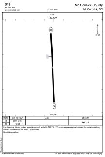
Runways:
| RWY identifier | QFU | Length (ft) | Width (ft) | Surface | LDA (ft) |
| 18 | 177° | 3598 | 75 | ASPH | |
| 36 | 357° | 3598 | 75 | ASPH |
Airport contact information
Address: Mc Cormick United States