


RORK - Kitadaito
Located in , Japan
ICAO - RORK, IATA - KTD
Data provided by AirmateGeneral information
Coordinates: N25°56'41" E131°19'37"
Elevation is 71 feet MSL.
View others Airports in Okinawa Prefecture
Operational data
Special qualification required
Current time UTC:
Current local time:
Weather
METAR: RORK 241900Z AUTO 21001KT 9999 FEW016 OVC021 23/21 Q1010
Communications frequencies: [VIEW]
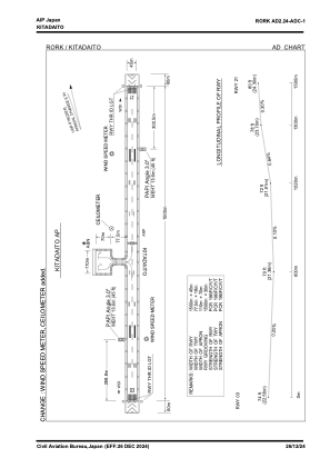
Runways:
| RWY identifier | QFU | Length (ft) | Width (ft) | Surface | LDA (ft) |
| 03 | 29° | 4921 | 148 | ASP | |
| 21 | 209° | 4921 | 148 | ASP |
Airport contact information
Address: Japan