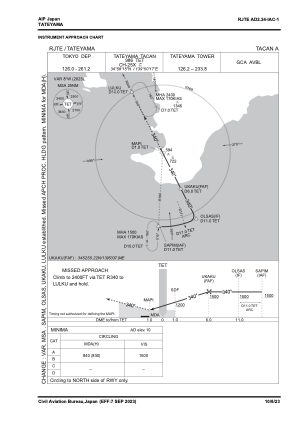


RJTE - Tateyama
Located in Tateyama, Japan
ICAO - RJTE, IATA -
Data provided by AirmateGeneral information
Coordinates: N34°59'15" E139°49'55"
Elevation is 10 feet MSL.
View others Airports in Chiba Prefecture
Operational data
Special qualification required
Current time UTC:
Current local time:
Weather
METAR: RJTE 162214Z 20004KT 140V250 8000 SHRA FEW015 BKN025 FEW025CB BKN060 18/17 Q1011 RMK 2CU015 6CU025 1CB025 7SC060 A2986 CB 30KM SW MOV E
Communications frequencies: [VIEW]
Runways:
| RWY identifier | QFU | Length (ft) | Width (ft) | Surface | LDA (ft) |
| 09 | 85° | 984 | 148 | CON | |
| 27 | 265° | 984 | 148 | CON |
Airport contact information
Address: Tateyama Japan