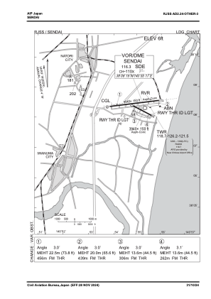
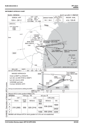
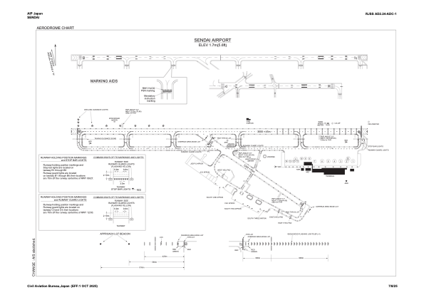


RJSS - Sendai
Located in Sendai, Japan
ICAO - RJSS, IATA - SDJ
Data provided by AirmateGeneral information
Coordinates: N38°8'23" E140°55'1"
Elevation is 6 feet MSL.
View others Airports in Miyagi Prefecture
Operational data
Special qualification required
Current time UTC:
Current local time:
Weather
METAR: RJSS 200813Z 32025G35KT 9999 FEW050 BKN/// 17/M05 Q1012 RMK 1CU050 A2989
TAF: TAF RJSS 200505Z 2006/2112 30016KT 9999 FEW030 TEMPO 2006/2008 30020G30KT BECMG 2011/2013 30004KT BECMG 2100/2103 14006KT
Communications frequencies: [VIEW]
Runways:
| RWY identifier | QFU | Length (ft) | Width (ft) | Surface | LDA (ft) |
| 09 | 83° | 9843 | 148 | ASP | |
| 27 | 263° | 9843 | 148 | ASP | |
| 12 | 118° | 3937 | 148 | ASP | |
| 30 | 298° | 3937 | 148 | ASP |
Airport contact information
Address: Sendai Japan