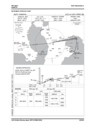


RJFY - Kanoya
Located in Kanoya, Japan
ICAO - RJFY, IATA -
Data provided by AirmateGeneral information
Coordinates: N31°22'5" E130°50'17"
Elevation is 202 feet MSL.
View others Airports in Kagoshima Prefecture
Operational data
Special qualification required
Current time UTC:
Current local time:
Communications frequencies: [VIEW]
Runways:
| RWY identifier | QFU | Length (ft) | Width (ft) | Surface | LDA (ft) |
| 08R | 79° | 7382 | 148 | CON | |
| 26L | 259° | 7382 | 148 | CON | |
| 08L | 79° | 3937 | 131 | CON | |
| 26R | 259° | 3937 | 131 | CON |
Airport contact information
Address: Kanoya Japan