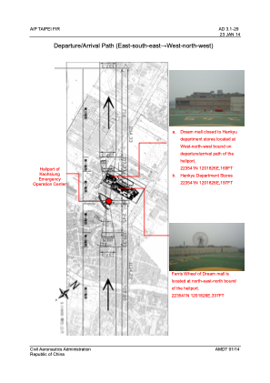


RCH15 - Kaohsiung Emergency Operation Center
Located in Kaohsiung, Taiwan, Province of China
ICAO - , IATA -
Data provided by AirmateGeneral information
Coordinates: N22°35'37" E120°18'26"
Elevation is 160 feet MSL.
Magnetic variation is -4° East View others Airports in Kaohsiung (municipality)
Operational data
Special qualification required
Current time UTC:
Current local time:
Weather at : RCKH - Kaohsiung Intl ( 5 km )
METAR: RCKH 191500Z VRB01KT 9999 FEW016 SCT050 27/23 Q1010 NOSIG RMK A2983
TAF: TAF RCKH 191100Z 1912/2018 19005KT 9999 FEW015 BKN032 TEMPO 1912/1916 26008KT TEMPO 1920/2001 05005KT TEMPO 2004/2010 26010KT BECMG 2010/2012 23005KT
Communications frequencies: [VIEW]
Runways:
Airport contact information
Address: Kaohsiung Taiwan, Province of China