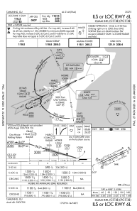
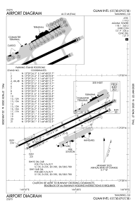


PGUM - Guam Intl
Located in Guam, Guam
ICAO - GUM, IATA - GUM
Data provided by AirmateGeneral information
Coordinates: N13°29'2" E144°47'50"
Elevation is 305 feet MSL.
Magnetic variation is 02° East View others Airports in (unassigned)
Operational data
Special qualification required
Current time UTC:
Current local time:
Weather
METAR: PGUM 232254Z 12005KT 5SM +RA BR FEW050 BKN085 OVC100 24/24 A2996 RMK AO2 SLP137 P0040 T02440244 $
TAF: PGUM 232302Z 2323/2424 12007KT 5SM -RA SCT015 BKN035 OVC100 TEMPO 2323/2401 2SM +SHRA FEW009 OVC015 FM240200 09012G20KT P6SM VCSH SCT018 BKN035 BKN120 FM240900 09009KT P6SM FEW018 SCT035 BKN130
Communications frequencies: [VIEW]
Runways:
| RWY identifier | QFU | Length (ft) | Width (ft) | Surface | LDA (ft) |
| 06R | 65° | 10014 | 150 | OTHER | 10014 |
| 24L | 245° | 10014 | 150 | OTHER | 8710 |
| 06L | 65° | 12014 | 150 | OTHER | |
| 24R | 245° | 12014 | 150 | OTHER |
Airport contact information
Address: Guam Guam
