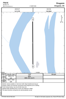


PAHX - Shageluk
Located in Shageluk,
ICAO - SHX, IATA - SHX
Data provided by AirmateGeneral information
Coordinates: N62°41'32" W159°34'9"
Elevation is 79 feet MSL.
Magnetic variation is 15° East View others Airports in Alaska
Operational data
Special qualification required
Current time UTC:
Current local time:
Weather
METAR: PAHX 252202Z AUTO 16006G14KT 10SM SCT030 BKN039 OVC050 07/01 A2983 RMK AO2 SLP102 T00670011
Communications frequencies: [VIEW]
Runways:
| RWY identifier | QFU | Length (ft) | Width (ft) | Surface | LDA (ft) |
| 16 | 180° | 3400 | 75 | OTHER | |
| 34 | 0° | 3400 | 75 | OTHER | |
| 18W | 0° | 5000 | 1000 | WATER | |
| 36W | 0° | 5000 | 1000 | WATER |
Airport contact information
Address: Shageluk