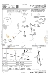
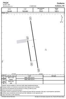


PAGK - Gulkana
Located in Gulkana,
ICAO - GKN, IATA - GKN
Data provided by AirmateGeneral information
Coordinates: N62°9'16" W145°27'19"
Elevation is 1586 feet MSL.
Magnetic variation is 17° East View others Airports in Alaska
Operational data
Special qualification required
Current time UTC:
Current local time:
Weather
METAR: PAGK 252053Z AUTO 13005KT 10SM CLR 09/M03 A2992 RMK AO2 RAB1954E05B26E44 SLP149 P0000 60000 T00941028 56006 TSNO
TAF: PAGK 251720Z 2518/2618 VRB03KT P6SM SKC FM260000 16010KT P6SM FEW200 FM261200 VRB03KT P6SM SCT200
Communications frequencies: [VIEW]
Runways:
| RWY identifier | QFU | Length (ft) | Width (ft) | Surface | LDA (ft) |
| 15L | 171° | 5001 | 100 | ASPH | |
| 33R | 351° | 5001 | 100 | ASPH | |
| 15R | 171° | 2300 | 60 | GRAVEL | |
| 33L | 351° | 2300 | 60 | GRAVEL |
Airport contact information
Address: Gulkana